
Harnessing Satellite Technology for Wildland Fire Response and Recovery

Over the past weeks, the United States has watched again as wildfires, the Palisades and Eaton fires destroy entire communities. It is a grim scenario that has become uncomfortably familiar. As we grapple with yet another disaster, the conversations on social media have quickly turned to critiques, debates, and calls for systemic change. While these discussions have their place, I wanted to take a moment to focus on something positive.
In the wake of disaster, I often think of how incredibly far technology has brought us in supporting disaster response and recovery. From satellite imagery to real-time damage assessments, advancements in data collection and geospatial tools are providing insights that really are making a difference.
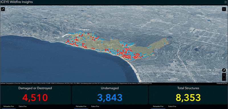
The dashboard below has resulted in a tool that exemplifies this progress: A 3D damage assessment dashboard. This application combines ICEYE satellite data with GIS technology to deliver rapid potential damage assessments for the areas impacted by the fires. This tool shines a light on what’s possible with technology today—offering communities the timely information they need to begin recovery efforts.
The Importance of Timely Damage Assessments
Timely damage assessments enable public safety agencies to allocate resources efficiently, prioritize areas in need, and expedite relief to affected communities. Communities and homeowners are also afforded closure more quickly. Traditional assessment methods, often reliant on door-to-door ground surveys, are time-consuming. In the case of the recent fires in California, persistent high winds for extended periods of time, grounded traditional airborne assets, impacting firefighting efforts and creating a blind spot for responders on the ground. Integrating satellite imagery and AI approaches into these assessments helps to fill gaps, while significantly enhancing both speed and accuracy.
As an example, in the case of the Palisades Fire, ICEYE acquired its first image and delivered its first results all within 24 hours of the first detection of smoke on the ground. The ICEYE team has continued to deliver updated results of impacted buildings for that fire twice daily while also imaging and analyzing the nearby Eaton and Hurst Fires.
ICEYE’s Satellite Data
ICEYE, a leader in synthetic aperture radar (SAR) technology and near real-time natural disaster insights, operates the world’s largest SAR satellite constellation. Their satellites capture high-resolution images with rapid revisit rates regardless of weather conditions, time of day, or smoke cover ensuring data collection capabilities during and immediately after disasters.
Accessing Satellite-Derived Insights for Public Safety Agencies
ICEYE’s Wildfire Insights (part of its portfolio of natural disaster analytical products) is an always-on service, delivering geospatial insights rather than radar imagery.
Public safety agencies seeking to utilize ICEYE’s Wildfire Insights need only contact ICEYE directly through their official website to express interest to establish service. ICEYE is already monitoring, targeting, and analyzing wildfires so agencies don’t need to delineate areas of interest or request acquisition timelines. A team of meteorologists, geospatial and remote sensing experts are constantly monitoring wildfire events and producing damage assessments for impactful events – and utilizing Esri’s ArcGIS technology throughout the process.
Once the analysis is produced, ICEYE’s insights can easily be integrated into ArcGIS Online or used within ArcGIS Pro for analysis.
Ground Verification and Response
The data utilized in this application isn’t just for looks, it was leveraged by responders across federal, state, and local agencies working the fires. It serves operational purposes including populating web maps with the damage classifications as a feature class. This means that agencies can give every responder in the field access to the baseline damage data with the ability to edit damage classifications directly from their mobile devices.
Moreover, putting this data into web maps can significantly aid other teams focused on search and rescue by delivering reliable locations with the most severe damage, enabling targeted search efforts and potentially saving lives.
View Authoritative Damage Assessment data from CAL FIRE here.
Learn more
To learn more about GIS for wildland fire, visit our solution page or download our ebook.
About the authors

Anthony Schultz
link


